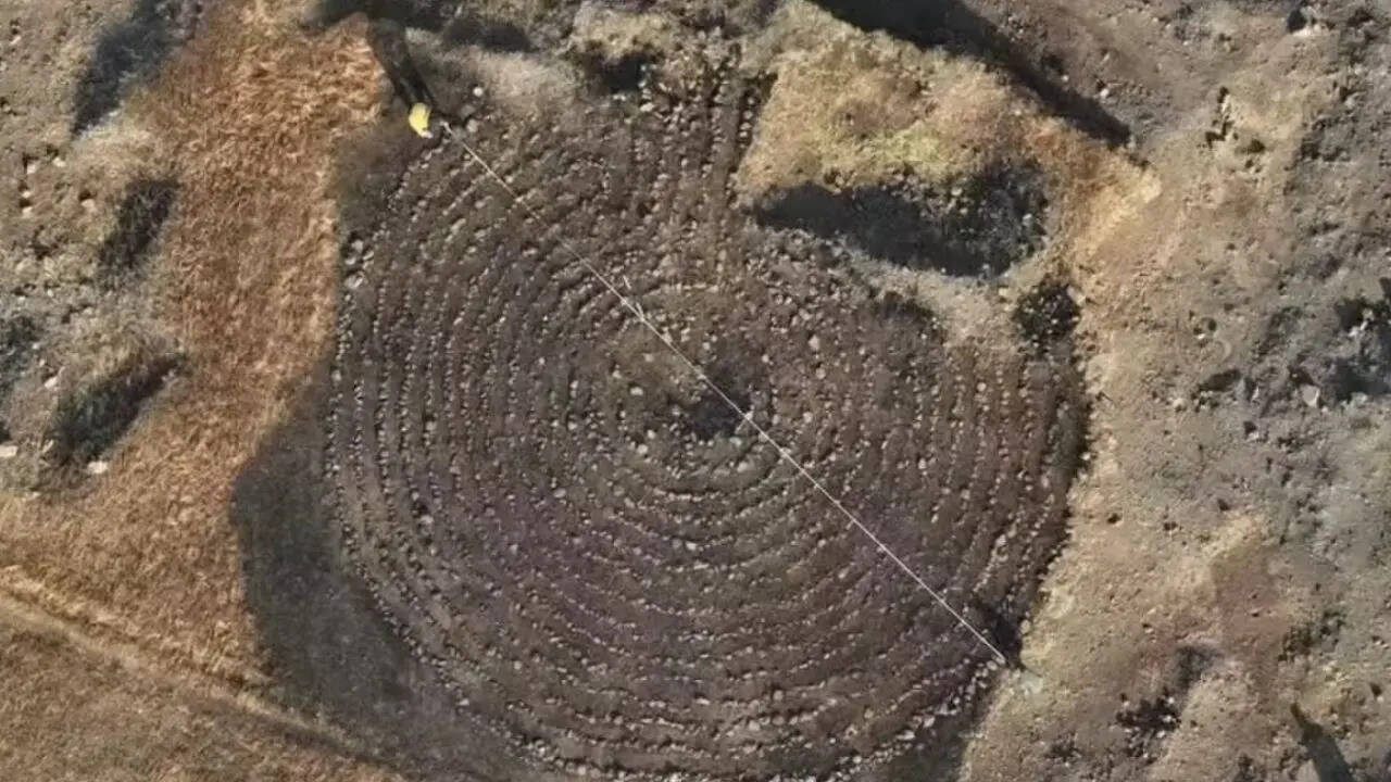
The discovery of a 15-circuit circular stone labyrinth in the Boramani grasslands of Solapur, Maharashtra, provides critical empirical evidence of the inland logistical infrastructure that supported Indo-Roman trade during the Satavahana era (c. 200 BCE – 200 CE). Measuring approximately 50 feet in diameter, this structure represents the largest circular labyrinth documented on the Indian subcontinent. Rather than viewing this artifact merely as a cultural anomaly or a religious curiosity, a structural analysis reveals its role as a high-visibility land navigation node. It functioned within a deliberate network designed to de-risk the transit of high-value commodities between the Arabian Sea ports and the production hubs of the deep Deccan interior.
The Spatial and Structural Mechanics of the Boramani Node
To understand the operational utility of the Boramani labyrinth, one must first isolate its structural components from speculative cultural narratives. The artifact exhibits a highly disciplined geometric layout: 15 concentric circuits constructed from small, deliberately placed stone blocks, terminating in a tightly coiled central spiral.
[Outer Perimeter: 50-foot Diameter]
  └── 15 Concentric Stone Circuits (Concentric Rings)
        └── Inward-Guiding Transit Path
              └── Central Coiled Spiral (Chakravyuha Typology)
This configuration combines two distinct architectural traditions. The overall topology matches the classical labyrinth family found throughout the Mediterranean basin, notably appearing on Cretan coinage used across the Roman Empire between the first and third centuries CE. However, the configuration modifies this Western template by embedding a tight spiral at the core. This central modification corresponds directly with the indigenous chakravyuha design—a geometric motif documented in early Sanskrit military and tactical texts.
The preservation of the site offers a distinct chronological baseline for its construction and usage window. Stratigraphic examination by Deccan College archaeologists revealed a uniform layer of undisturbed soil accumulation measuring roughly 1.5 inches between the stone rings. In a semi-arid grassland ecosystem subject to continuous wind erosion and periodic alluvial deposition, the depth and stability of this sediment interface indicate that the stone boundaries remained physically undisturbed for approximately two millennia. This matches the zenith of the Satavahana dynasty's territorial control over the Deccan plateau.
The Deccan Transit Corridor as a Cost Function Problem
The presence of Mediterranean design principles in the Solapur district cannot be explained by casual cultural diffusion. It requires an economic explanation rooted in transactional risk and logistics. During the early centuries of the Common Era, Indo-Roman commerce operated as a highly integrated, capital-intensive macro-system.
Western merchants arriving at western Indian ports such as Kalyan, Sopara, and Chaul faced an immediate logistical bottleneck: the physical extraction of goods from interior production centers like Ter (ancient Tagara), Karad, and Kolhapur required traversing the rugged topography of the Western Ghats and the vast, featureless expanses of the Deccan plateau.
This supply chain can be modeled through an explicit risk-cost function where total transit risk ($R_t$) is determined by three core variables:
$$R_t = f(I_c, N_e, P_v)$$
Where:
- $I_c$ represents infrastructural constraints (topography, seasonality, trail visibility).
- $N_e$ represents navigational errors (losses from off-route delays, water scarcity, or entering hostile territories).
- $P_v$ represents the high intrinsic value of the cargo itself, which acted as a multiplier for security liabilities.
The cargo moving eastward into the interior consisted primarily of Roman gold (denarii), Italian and Aegean wines transported in amphorae, and high-end Mediterranean coral and ornamental ornaments. The return cargo moving westward to the coast featured dense, high-weight or high-volume commodities: black pepper from the hills, fine cotton textiles, silk, and indigo dyes.
Because the inland routes lacked the definitive paved infrastructure of domestic Roman roads, merchants relied heavily on native overland tracks. In the semi-arid grasslands of Solapur, these tracks frequently faded due to shifting topsoil and seasonal monsoonal overgrowth.
Navigational Signposts and Network Interoperability
The Boramani labyrinth addresses the $N_e$ variable (navigational error) within the risk equation. It did not operate in isolation. Archaeologists have previously identified a sequence of smaller, structurally related stone labyrinths distributed across the Satara, Sangli, and Kolhapur districts. When plotted geographically, these sites form a clear linear alignment that mirrors the natural trade corridors linking the coastal entry points to the major market city of Ter.
The systemic placement of these structures suggests they functioned as high-permanence, unmistakable geographic markers—effectively serving as ancient visual waypoints. For an inland caravan managing hundreds of pack animals or draft oxen laden with high-value Roman bullion, hitting a known waypoint was a critical validation step. It confirmed that the caravan remained on the optimal transit vector where water, security garrisons, and fodder were predictable.
The integration of Roman and indigenous design motifs at the Boramani node suggests a deliberate strategy of network interoperability between foreign merchant syndicates and local Satavahana authorities.
- For the Roman Agent: The familiar classical design of the outer circuits signaled an established, certified trading zone or a point of clear alignment with Mediterranean mercantile interests.
- For the Local Operator: The central chakravyuha spiral anchored the site within native spiritual, defensive, or administrative frameworks, ensuring the local population respected the sanctity and neutrality of the transit node.
Architectural Trade-offs: Square vs. Circular Geometries
The scale of the Boramani labyrinth is best understood by contrasting it with India's other mega-labyrinth: the square stone formation at Gedimedu in Tamil Nadu. The Gedimedu structure covers a slightly larger total square area (measuring roughly 56 feet across) but utilizes a strict orthogonal layout.
The selection of a circular geometry for the Boramani site carries specific operational advantages for a grassland waypoint:
- Omnidirectional Visibility: A circular structure with a 50-foot diameter maintains structural symmetry from any angle of approach. In an open grassland landscape, this minimizes distortion for an observer scanning the horizon from a distance, unlike a square structure which can appear compressed or narrow when approached obliquely.
- Construction Efficiency: Laying out 15 concentric circles requires only a central anchor point and a standardized tether line to maintain uniform radius increments. This allowed ancient engineers to execute high geometric precision using irregular, local stone blocks without requiring specialized quarrying or dressing equipment.
- Traffic Management: The continuous, curving pathways of a circular labyrinth naturally distribute foot traffic and minimize structural wear at sharp corners—a structural vulnerability inherent to square designs when subjected to use by heavy caravans.
Empirical Corroboration of Roman Penetration
The hypothesis that the Boramani labyrinth operated as a vital node in an Indo-Roman commercial network is corroborated by concrete material finds across the region. The Deccan transit route has yielded significant assemblages of Western artifacts that confirm the deep penetration of Mediterranean wealth into the interior:
- The Brahmapuri Assemblage (1945): Excavations at Brahmapuri near Kolhapur uncovered an elite collection of Roman bronzes, including a finely detailed statuette of the Greco-Roman sea deity Poseidon, alongside a polished bronze mirror of distinct Western manufacture.
- The Ter Excavations: Digs at the ancient market hub of Tagara (Ter) revealed Roman clay bullae, local pottery imitating Mediterranean Arretine ware, and fragments of authentic Roman amphorae containing residues of imported olive oil and wine.
- Numismatic Inflow: The discovery of Roman gold coins across the Deccan plateau—frequently counter-struck by Satavahana rulers to assert local sovereignty while preserving the metal's intrinsic value—proves a continuous, high-volume settlement of accounts using imperial currency.
These items demonstrate that Western traders or their direct agents were not confined to coastal emporia like Muziris or Arikamedu. They moved inland along defined trade channels, carrying their habits, material culture, and symbolic architecture with them.
The Strategic Outlook for Deccan Lineage Mapping
The identification of the Boramani labyrinth requires a fundamental shift in how ancient Indian logistics are analyzed. Rather than treating early trade routes as loose, adaptive paths, researchers must model them as highly structured, intentionally engineered corridors.
The immediate imperative for field archaeology involves applying predictive GIS (Geographic Information Systems) modeling to the Solapur-Satara-Sangli belt. By cross-referencing the exact coordinates of the known labyrinth sites with natural water sources, elevation profiles, and documented Satavahana coin hoards, it will be possible to map the precise path of this ancient "Western Deccan Silk Road."
Unlocking the location of the remaining hidden waypoints along this line will clarify how ancient state power was utilized to standardize, secure, and tax the international trade flows that linked the markets of Rome with the resources of ancient India.